A short time after Hurricane Michael passed through here in Panama City, Fla. we saw planes flying overhead but no one was sure what they were up to.
Turns out they were taking ultra-high resolution photos of all the damage below for the public, first responders and member companies of the National Insurance Crime Bureau.
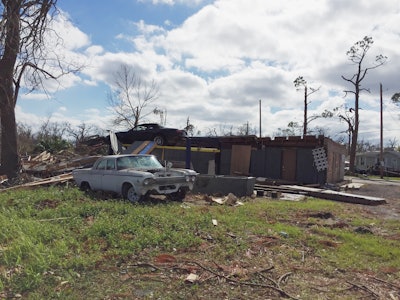
So many homes, businesses and vehicles were damaged and even destroyed by the historic category four storm. The photo above shows a shop that lost part of its building where its vehicle lift was located. There’s a car still perched up high where it was left before the storm struck on Oct. 10. Not far from where my daughter took this picture our home and car were damaged and flooded.
For NICB member companies the photos provided by the Geospatial Intelligence Center (GIC) following Hurricanes Florence and Michael helped enhance insurers efforts to respond to their impacted customers.
The efforts of the GIC are documented in the video below produced by the NICB. Other property damaged by Hurricane Michael in Panama City is shown below.
GIC imagery was collected by a fleet of airplanes, each equipped with a $1.5 million Vexcel Imaging sensor. The planes were in the air as soon a weather permitted after the hurricanes providing images and data to GIC member companies within 24-36 hours of the flights.
This provides insurers with vital information that helps them respond and pay claims faster to help victims get on the road to recovery. The imagery is also provided at no charge to emergency personnel, first responders and law enforcement to assist in their response to the damage.
The public can also view before and after images of impacted areas on an address-by-address basis by going here.
The GIC has also mapped the areas hardest hit by previous hurricanes and disasters and those views are also available. This effort is part of the massive data collection and processing system spearheaded by the NICB whose member companies write almost 80 percent of all property/casualty insurance and over 94 percent of all auto insurance in the country.
On a regular basis, the GIC is in the process of collecting high-resolution “before” benchmark imagery on the ground and in the air in some 100 markets. Through a network of aviation companies, the GIC is prepared to reach any disaster area in the U.S. within two hours and can begin imagery collection as soon as it is safe to fly and skies have cleared.